

Lead Writer:
Sabrina Delgado Arias
How can ICESat-2 potentially contribute to Sage Grouse conservation and sagebrush land management decisions?
Protecting a Charismatic Bird
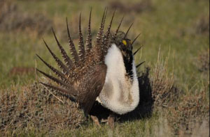
The Greater Sage Grouse is a species native to the sagebrush-steppe ecosystem of the western United States. This charismatic bird is recognized as the ambassador of the sagebrush landscape, and acts as both an umbrella species for conservation (potentially protecting other sagebrush dependent fauna) and as an indicator of the health of its semiarid ecosystem. Currently occupying 668,412 km2 in 11 western states and two Canadian provinces – 56 percent of its historic range – the Greater Sage Grouse is threatened by the increasing fragmentation, degradation, and loss of its sagebrush habitat. Sagebrush provides nesting and brood-rearing cover, as well as migratory corridors, and is also the primary component of the sage grouse diet—in the winter sagebrush is the only available food source.
Greater Sage Grouse conservation efforts must take into account the various complex stresses on the sagebrush ecosystem and the highly contested uses for the landscape. Sagebrush ecosystems face increasing fire-invasive grass cycles (after a fire, non-native fire-prone annuals suppress the establishment of the slower to regenerate native shrub-steppe plants); encroachment of annual grasses, noxious perennials, and native conifers; increasing demand of the land for agriculture and energy development, as well as climate change. All of these contribute to increased alteration and fragmentation of the sagebrush ecosystem. Therefore, conservation efforts for the Greater Sage Grouse are of interest to a variety of stakeholders, including government agencies (e.g. the U.S. Geological Survey (USGS), U.S. Fish & Wildlife, U.S. Forest Service (USFS), and Bureau of Land Management(BLM)), ranchers, mining and logging companies (e.g. Oregon Cattlemen’s Association, Goldcorp), energy firms, tribal governments, NGOs and private landowners.
Needed Measurements
Characterizing shrubland components, such as sagebrush, with remote sensing is one of the main efforts being investigated for the management of the Greater Sage Grouse habitat. The USGS and the BLM, for example, are collaborating to provide an estimate, based on remote sensing at 30-meter resolution, of the canopy cover of shrubland components, including sagebrush height, litter, and bare ground. This will help identify and protect the Sage Grouse habitat. Researchers are investigating how LIDAR (remote sensing method to measure distances) measurements can be used to provide better estimates of actual sagebrush heights and densities, especially at scales derived from satellite-based laser altimetry.
The NASA Response
NASA’s Ice, Cloud and Land Elevation Satellite-2 (ICESat-2) will measure global vegetation. The mission has a baseline science requirement to measure global vegetation height with a ground track spacing of less than 2 km over a 2-year period. A number of Early Adopters approved by the ICESat-2 Mission in 2013 and 2014 are conducting prelaunch research to determine the utility of ICESat-2 for the characterization of vegetation. The Early Adopters agree to partner with one or more end-users to incorporate their research into a specific decision-making process. Early Adopters from the Boise Center Aerospace Laboratory (BCAL), for example, receive direct funding from the BLM, the USGS, the Department of Defense, and the Joint Fire Sciences Program for improved mapping of biomass and percent cover of sagebrush-steppe. Early Adopters from BCAL will conduct pre-launch research to determine the potential of ICESat-2, either independently or with data from other instruments, to quantify aboveground biomass of semiarid ecosystem vegetation. Their goal is to use estimates of biomass to quantify carbon, fuel loads, and monitor change in regions such as the Great Basin of the western United States. By quantifying the composition and structural variability of short-statured semiarid vegetation, BCAL expects to contribute to the need for long-term land management and understanding of ecosystem vulnerability, including understanding the vulnerability of sage grouse habitat to fragmentation-how connected are the Sage Grouse habitat corridors?
Comments? Thoughts?
For additional information about ICESat-2 mission applications or this particular application, please contact ICESat-2 Applications Team at icesat-2-applications@lists.nasa.gov.