

In addition to the icy parts of our planet, ICESat-2 also surveys the heights of the world’s trees and forests. Other Earth-observing satellites, such as Landsat and MODIS, allow researchers to study the location and extent of trees and forests; ICESat-2 allows them to add the height. NASA, in partnership with the GLOBE Program, has developed several ways that students, teachers, and citizen scientists can measure tree height from the ground, while the ICESat-2 satellite measures tree height from space. Get involved with the newly released Trees Community Challenge.

The year round Trees Around the GLOBE Student Research Campaign is a citizen science program for students and educators from around the world. This campaign highlights measurements of tree height and focuses on the scientific, cultural, and personal foundation of trees. After students take and collect data, their goal is to make sense of their data and develop presentations, posters, and research projects based on their data and data analysis. Students can also visualize and retrieve additional GLOBE Program data for use in these research projects.
One of the major components are the monthly science research and educational webinars. Each month the campaign webinars focus on the scientific research of trees, land cover and/or greenings, bringing in experts from around the world to share their current research experiences and the importance of the GLOBE protocol measurements to understanding our planet's trees and their roles in our Earth's ecosystem. During the webinars, researchers from inside and outside of NASA, GLOBE Students and Teachers, and Citizen Scientists are featured.
Click on the image above to visit the Trees Around the GLOBE Student Research Campaign Webinar page.
The campaign commenced on September 15, 2018 in conjunction with NASA's ICESat-2 satellite launch on the same date at 6:02am PDT. Currently, the fourth year of the campaign brings together student research, online tools and datasets for data analysis, comparisons to satellite data, and the development of student research projects for local science fairs, United States SRS, and GLOBE IVSS. Even though this campaign is focused on tree height, there are a lot of other GLOBE measurement protocols that complement your tree height measurements.
This campaign is a student research campaign focusing on tree height - one of the measurements conducted by the ICESat-2 mission. Tree height is not just a measurement - it is a gateway to understanding many things about the environment. The structure of tree canopies, the 3D arrangement of individual trees, has a huge effect on how ecosystems function and cycle through carbon, water, and nutrients.
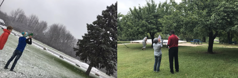
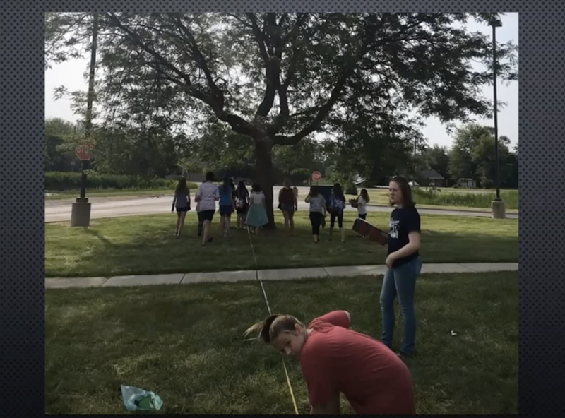
Taking Tree Height Measurements: (left) Students from Shumate Middle School in Gibraltar, Michigan and (right) Educators from Prince Georges County, Maryland.
In order to put the tree height measurements into context, we are recommending students to also take measurements of Land Cover Classification, Green Up / Green Down, and Carbon Cycle. This will allow for data research comparisons among several GLOBE environmental measurements.
Students are also encouraged to take baseline protocol measurements in their local environments. Some examples are: Air Temperature, Surface Temperature, and Soil Temperature,
One of the major foundations of the campaign are interactive webinars. Each month the campaign webinar will focus on the scientific research of trees, bringing in experts from around the world to share their current research experiences with trees and the importance of the GLOBE protocol measurements to understanding our planet's trees and their roles in our Earth's ecosystem. During the webinars, we will hear from researchers, students, educators, and citizen scientists from inside and outside of NASA.
Click on the image above to view the Trees Around the GLOBE Student Research Campaign Promotional Video
__________
Check out the 2023 NASA Moon Trees Quest at https://observer.globe.gov/nasa-moon-trees-quest. The GLOBE Program's GLOBE Observer, in collaboration with NASA Next Gen STEM and the USDA Forest Service . The event ran from June 21 - September 21, 2023, for Apollo 14 Moon Trees and related tree species. This activity was part of a collaborative STEM Engagement initiative to inspire the Artemis generation .
__________
NASA GLOBE Observer Trees Tool
The Trees observation allows citizen scientists to measure tree height for as many trees as the observer wants. You can track the growth of trees over time and even take observations at the same time the NASA Ice, Cloud, and land Elevation Satellite-2 (ICESat-2) and the Global Ecosystem Dynamics Investigation (GEDI) instrument onboard the International Space Station are taking measurements of tree height from space. During your observation of tree height, you can also measure the tree circumference. Tree height is the most widely used indicator of an ecosystem’s ability to grow trees. Observing tree height allows NASA scientists to understand the gain or loss of biomass which can inform calculations of the carbon that trees and forests either take in from or release into the atmosphere.
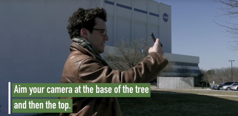
Click on the image above to view the NASA GLOBE Observer Trees Tool Promotional Video
Comparing Paper Clinometer Tree Height Measurements to NASA GLOBE Observer Tree Tool Tree Height Observations
Did you know that you can meaure the height of a tree using a hand-held clinometer (an instrument used for measuring the angle or elevation of slopes) and compare that measurement to the tree height observation you got using the NASA GLOBE Observer Trees Tool? First, let's see "How to Build and Use a Simple, Paper Clinometer!"
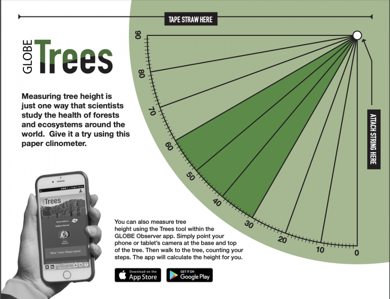
Image of a Paper Clinometer
Once you get the knack of how to take tree height meaurements using the paper clinometer, you can then compare them to the heights taken of trees using the NASA GLOBE Observer Trees Tool. Here is an activity called, "Tree Height Comparisons: Hand-Held Clinometer vs. the NASA GLOBE Observer: Trees Tool!"
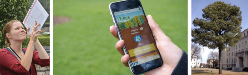
(Left) Using a paper clinometer, (middle) the NASA GLOBE Observer Trees Tool, and (right) a tree for observation
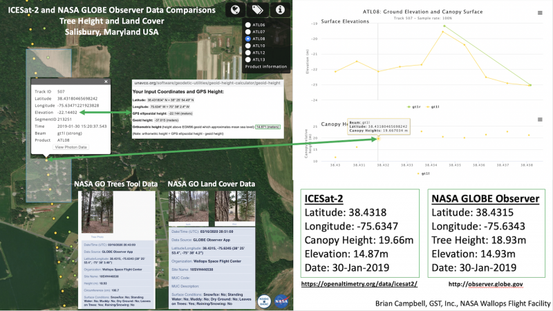
Comparing GLOBE Tree Height Data to ICESat-2 Tree and Canopy Height Data
Students, teachers, and citizen scientists can take existing GLOBE Observer data for tree height and compare it to the tree canopy height data from the NASA Ice, Cloud, and land Elevation Satellite- or ICESat-2 Mission. The online Open Altimetry Tool allows you to look and see when ICESat-2 flew over or near the location of the tree you have the GLOBE data for already. It is a fun and simple thing to do and helps you become a part of a larger NASA mission.
Click on the image above to view a virtual demo on how to compare GLOBE and ICESat-2 tree height data.
Because the Advanced Topographic Laser Altimeter System or ATLAS, onboard ICESat-2, is sensitive enough to detect individual photons, and has such a rapid firing rate, the instrument is be able to detect both the forest floor and the tops of tree canopies in all but the densest woods and jungles.
Tracking how trees are changing over time can help us estimate the number of trees that make up an area. Tree height is the most widely used indicator of an ecosystem’s ability to grow trees. Observing tree height allows NASA scientists to understand the gain or loss of biomass which can inform calculations of the carbon that trees and forests either take in from or release into the atmosphere.
If you would like additional information on either the Trees Around the GLOBE Student Research Campaign or the NASA GLOBE Observer Trees Tool, please contact Brian Campbell.