

How can ICESat-2 contribute to the modeling of sensitive bird habitat in forests?
Identifying Bird Habitat
Determining the habitat for a bird species requires understanding of the plant life, landforms, and climate that make up the four necessities for a bird’s survival: food, water, shelter and nesting sites. Usually mapping bird habitat requires time-consuming field work, involving many specialists working at a very detailed level, often in inaccessible or dangerous terrain. Satellite remote sensing promises to provide a cost-effective and innovative way to target this field work and enable much more frequent habitat mapping than once every five years.
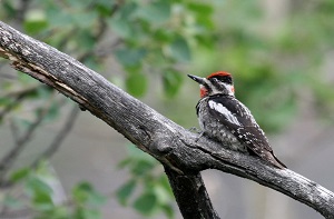
Lidar, provides parameters directly related to the vertical heterogeneity of a forest, which is, in turn, highly related to habitat quality and suitability, as discerned from field investigations for a wide range of species. The ability to map sub-dominant species such as dense shrub layers in forests, lying and standing deadwood, bare surfaces, and fields are extremely useful for the classification of species habitats and structures that confer habitat quality. Woodpeckers, for example, thrive in areas with dense undergrowth and fallen trees.
Who Cares and Why?
Birds are a source of inspiration and fulfilment for many people. They are also an intricate component of the ecosystems we need for our own survival. Ecosystems such as forests and grasslands provide us with food, medicines and important raw materials, oxygenate the air and remove pollutants from water. Birds play an important role in the effective functioning of these systems.
The lack of information about three-dimensional structure in forests limits our ability to monitor and manage bird species in these ecosystems and to conserve scarce habitat. Because they are sensitive to habitat change and are easy to census, birds are an important tool for ecologists to measure the health of forest ecosystems. Whether these ecosystems are managed for agriculture, wildlife, water or tourism, successful management can be measured by the health and diversity of bird populations. Satellite remote sensing information can greatly increase the frequency and accuracy of habitat monitoring and the identification of change as it occurs.
Needed Measurements
During the last two decades, high resolution visible/near infrared remote sensing data have been used to successfully characterize relevant aspects of forested habitats over broad areas, but have been typically unable to describe three-dimensional (3-D) structural characteristics. Lidar data can provide critical new information on canopy structure and vegetation characteristics to estimate forest habitats. Datasets are needed that will provide information on canopy height, understory vegetation, and the amount of fallen trees and other snags that form many birds’ food and nesting habitats.
Improved habitat quality maps that capture the vertically and horizontally complex forest systems supporting woodpeckers would enable more rapid and continuous assessment of changes in bird habitat. Satellite remote sensing that provides information about this complexity will be extremely valuable to better understand bird diversity and population change.
The NASA Response
Launching in 2018, the Ice, Cloud and Land Elevation Satellite-2 (ICESat-2) mission will use one of the most spatially dense and high precision active remote sensing instruments for global measurement of surface elevation. The micro-pulse, multi-beam Advanced Topographic Laser Altimeter System (ATLAS) instrument will provide global terrain elevation, global canopy heights, and global canopy cover at 100-m resolution. Coupled with other data sources (e.g., Landsat), ICESat-2 could allow for the consistent representation of canopy structure relevant to bird habitat across the entire United States.
Several researchers are working to incorporate Lidar data into bird habitat models, both in the United States and in Europe. Recent results suggest denser spatial sampling in satellite-based Lidar missions, such as that offered by ICESat-2, will help improve mapping and modeling of wildlife distributions across the globe, especially when combined with airborne data. Coincident airborne and satellite Lidar sampling will be needed to demonstrate the suitability of new data to derive structural metrics at ecologically meaningful scales.
Comments? Thoughts?
For additional information about ICESat-2 mission applications or this particular application please contact Molly Brown at mbrown52@umd.edu.