

How can ICESat-2 contribute to mitigating volcanic events?
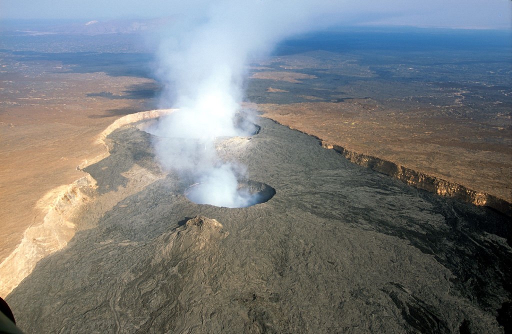
Image of Erta Ale, Ethiopia (from image commons).
Identifying and Monitoring Volcanos
Volcanic eruptions are one of the Earth’s most dramatic and extreme hazards. Volcano hazards include lava flows, heavy ash fall, pyroclastic mixtures of hot gas and ash, pumice falls and toxic gases released during an eruption. Direct hazards to people can be avoided with early warning of the possible eruption’s timing and intensity. Volcanic eruptions can destroy homes, lava flows can cut off roads and evacuation routes, and damage communication networks. These hazards can occur over hours or weeks, depending on the speed and intensity of the eruption.
Evacuation of communities around volcanos can be challenging since areas downwind from an active volcanic eruption can be hazardous or not passable. Knowing the degree of volcanic unrest and what areas might be impacted can greatly facilitate decisions about which communities need to evacuate and how far away they need to go. Knowledge of the volcano’s previous history and status is critical for designing and implementing emergency plans.
Communities near volcanos are not the only subjects at risk. Volcanic ash is very dangerous for modern aircraft. Modern airplane engines operate at temperatures high enough to melt any ash that is drawn into the engine. As the liquid particles move into regions of the engine that are less hot, they solidify and block air flow and cause the malfunctioning of the engine. This means that any large-scale eruption that ejects ash into the atmosphere needs to be carefully monitored and flights routed around the ash cloud.
Who Cares and Why?
Information about an imminent volcanic eruption can prevent catastrophic damage to life and property by estimating when an eruption might occur, the type of the eruption, and how volcanic debris may spread. Recent use of thermal data from daily observations provided by the Moderate Resolution Imaging Spectroradiometer (MODIS) sensor has greatly increased the ability of scientists to detect volcanic unrest in the form of increased surface temperatures, indicating near-surface magma and the possible threat of an eruption.
Data from Synthetic Aperture Radar (SAR) systems and altimeters such as the upcoming, Ice, Cloud and Land Elevation Satellite-2 (ICESat-2) mission, are well-suited to look at physical changes that precede an eruption; for example, changes in elevation around a volcano due to the intrusion of magma into the near-surface regions. Topographic changes in an area around an active volcano are also important to measure, as the direction that volcanic emissions travel is controlled by the surrounding topography. An increase in elevation on one side of a volcano containing in-filled valleys may result in a different hazard compared to a side with steep slopes. Flat regions or in-filled valleys are less able to contain volcanic mass flows such as pyroclastic density currents (high concentration avalanches of hot volcanic rock and gas) and lahars (fast moving and deadly mudflows), which may threaten surrounding communities. Steep slopes can increase the mobility of volcanic debris. Monitoring the topography of a summit can provide key evacuation guidance during a volcanic eruption.
Needed Measurements
ICESat-2’s extremely accurate elevation data can improve analysis of volcanic hazards. The mission’s Surface Elevation Reconstruction and Change detection (SERAC) approach was developed to combine multi-platform laser altimetry data on ice sheets into time series of elevation changes from all observations within a surface patch using least-squares adjustment. Thickness changes over time are approximated by analytical curves to derive elevation change rates.
Applied to volcanoes, this method could not only be used to detect volcanic cone inflation for use in eruption forecasting, but also could provide data necessary to model magma chamber processes. ICESat-2 data may be used to improve the elevation data around volcanoes that have not been monitored previously, reducing errors and uncertainty in hazard models used to estimate the possible movement of volcanic mass flows across the landscape.
The NASA Response
Launching in 2018, the ICESat-2 mission will use one of the most spatially dense and high precision active remote sensing instruments for global measurement of surface elevation. The micro-pulse, multi-beam Advanced Topographic Laser Altimeter System (ATLAS) instrument will provide global surface heights averaged along 40-m segments of ground track.
Early Adopter Greg Babonis of the State University of New York Buffalo is working on methods to complement the MODVOLC system, which uses near-real time satellite monitoring to detect volcanism worldwide. There are 1500 potentially active volcanoes worldwide, of which 500 are active at any given time. Using satellite observations, we can quickly identify where, when and why eruptions occur and enable the observations of changes to the land around the volcano before it erupts. Such observations are particularly important for observing extremely remote volcanoes.
Comments? Thoughts?
For additional information about ICESat-2 mission applications or this particular application please contact Molly Brown at mbrown52@umd.edu.